Location: Near Crawfordsville in Washington County, Iowa

Description: The site has eight plots with two replications for each treatment. Individual plots range in size from approximately 1.2 to 2.4 ha (3 to 6 ac) for a total project area of 17 ha (42 ac). Plots are split down the middle and cropped east to west with both corn and soybeans each year, which are alternated each consecutive year to replicate a typical corn-soybean rotation in Iowa.
Background: The site is 273 acres, consisting of the initial purchase in 1987 and adjacent tract acquired in 2002. The site carries weather summary data for the past 54 years.
Soils: Taintor (silty clay loam, fine, smectitic, mesic Vertic Argiaquolls) and Kalona (silty clay loam, fine, smectitic, mesic Vertic Endoaquolls) soils.
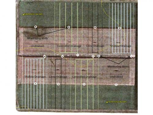
Drainage Design: This site is designed to compare conventional, controlled and shallow drainage. The eight plots include two undrained plots, two plots with conventional drainage, two plots with shallow drainage, and two plots with controlled drainage. The conventional and controlled drainage plots have tiles installed to a 1.2 m (4 ft) depth with a drain spacing of 18 m (60 ft). Shallow drainage plots have tiles installed to a 0.76 m (2.5 ft) depth with a 12.2m (40 ft) spacing. All drained plots were designed to have a maximum drainage coefficient of 1.9 cm d–1 (0.75 in day-1). Tile lines for all plots were laid out in a north-south orientation.

Figure 2: Crawfordsville plot layout and drainage design

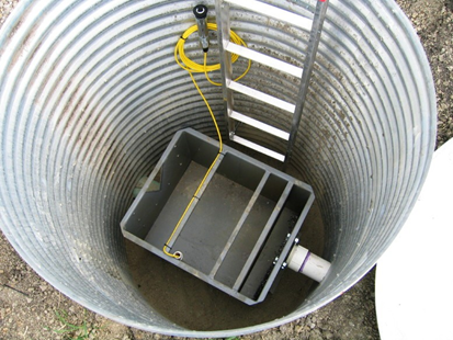
Figure 3: Crawfordsville monitoring sump design
